Summary
‘If you don't want to build dykes, you have to leave’ was the motto of the farmers who settled in the Vier- und Marschlande region centuries ago. They had to protect their land and farms from Elbe floods. However, the history of dyke construction along the river is also marked by devastating breaches. These breaches allowed water to rush into the hinterland with enormous force, creating deep depressions known as 'bracks'. These bracks remained behind the rebuilt dykes and are now a typical feature of the Elbe marshlands. Many of the bracks have been filled in or have silted up naturally. Their former locations are clearly visible in the curves of the old dykes today.
The Kiebitzbrack, located in the south-eastern Vier- und Marschlande and after which the nature reserve is named, has been preserved in almost its original state.
Description
The 35-hectare nature reserve is characterised by the brack with dense reed beds, an alder swamp forest and grasslands, as well as a small coniferous forest in the west. The characteristic vegetation of the nature reserve includes reeds and large sedges, as well as some accompanying species such as marsh grass and swan flower, in contrast to the conifers which are alien to the landscape. The large populations of water lilies are particularly striking, their bright yellow flowers floating on the water from late spring to autumn.
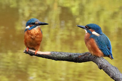
The nature reserve is home to endangered amphibians and reptiles such as moor frogs, grass snakes and viviparous lizards. The extensive reed beds and alder swamp forest provide a habitat for numerous bird species, including the rare reed warbler, kingfisher and western marsh harrier. Large birds, such as storks and grey herons, come here to search for food.
Life in the brackish water, which is up to ten metres deep, is interesting. The steep walls of the former vortex hole prevent the wind from circulating the water down to greater depths. In summer, this results in stable stratification of the water, with a warm surface layer around 1.5 metres thick. Beneath this, the temperature drops significantly to around 8°C at a depth of six metres. Below 2.5 metres, there is already a severe lack of oxygen, meaning the water below is largely lifeless. However, the warm, oxygen-rich upper layer is teeming with fish. Fourteen species have been identified here, including the common rudd, the belica, the common bream, the spined loach and the weatherfish.